Hikers who cherish forests filled with small waterfalls, streams and wild rivers will discover many treasures in the midst of the mountain terrain at DeSoto State Park.
Near Fort Payne and Mentone in the northeast corner of Alabama, the beautiful park is sandwiched between the crest of Lookout Mountain and the West Fork of Little River.
It’s easy to consider it the state’s best state park for getting a closeup look at cascading streams and creeks as they plunge through the highlands.
Hiking trails featured below include:
DeSoto Scout Trail
White Trail
Talmadge Butler Boardwalk Trail
Blue Trail
Orange Trail
Aqua Trail
The trail to the bottom of DeSoto Falls
There are several other trails, but I consider most of them to be connectors or less-scenic mountain-biking trails.
Whether you are vacationing in the area, visiting for the weekend, or just wanting to connect with nature on a Saturday morning, this article can help you plan an unforgettable hike. Trail runners should like most of these trails, too. Please find featured trail information below which includes:
Trail descriptions with highlights and points of interest
Experience the sights and sounds of a wild river from the DeSoto Scout Trail
Persons who like to explore the banks of big creeks or small rivers will love this trail, which is marked by yellow blazes. The trail stays very close the river for hundreds of yards, and there are dozens of spots where you can stand on a boulder or rock layer directly on the water’s edge. The sound can be the best part.
In addition, it would be difficult to find a path where you would see more rhododendron and mountain laurel than on the DeSoto Scout Trail (DST). The big flowering plants grow wild and dense here. From late May to mid-summer, you can hike in some places where the blooms and leaves are so thick they seem to form a tunnel.
A good number of tulip poplar trees can also be found in bloom around the same time of year. Birdwatchers should remember to watch and listen for kingfishers.
Gallery: DeSoto Scout Trail/West Fork of Little River
I live close enough to this state park to often come up with an excuse to take a hike there, and because of the river, this trail is the one that draws me back most often.
Only about 1.35 miles of the DeSoto Scout Trail (DST) is within the state park borders. But the DST, which — other than some presently overgrown sections — runs parallel to the river from the Camp Comer Boy Scout Reservation property to Little River Falls.
To the north, the trail follows the river through the woods to the scout reservation property. But, you step into private property when you cross the state park border. To the south, the trail can take you deep into the backcountry portion of Little River Canyon National Preserve, which is federal government lands.
If you hike far enough into the national preserve, you will move into an area where the DST becomes more and more taken over by nature, and where black bears are now known to reside. At the present time, to go over about 4-5 miles — and to see the miles of river that few people have seen between where the East and West Fork converge and Hwy. 35 — it becomes necessary to use the backcountry dirt road or to go where the trail is not recognizable.
Revitalization efforts are ongoing in the overgrown areas, according to the trail’s Facebook page.
The pictures in the gallery above are from the south side of the Indian Falls. Here’s a few from the north side:
The north portion of the DST between Indian Falls and the park border stretches for only about 0.48 miles, one way. In contrast to the south side, this portion does not provide access to the river. It closely parallels the river, but you will be hiking along the top of a 40-50 foot bluff rather than the water’s edge.
There are several short trails that provide access to the DST. The DST has a few steep sections, but most those short trails are steeper. Two short, steep trails from the main picnic area aren’t shown on trail maps, but they are excellent for entering or exiting the DST.
You can get to the DST from a short path that leads from the parkway to Indian Falls. Look for the Indian Falls sign on the wastewater plant’s fence.
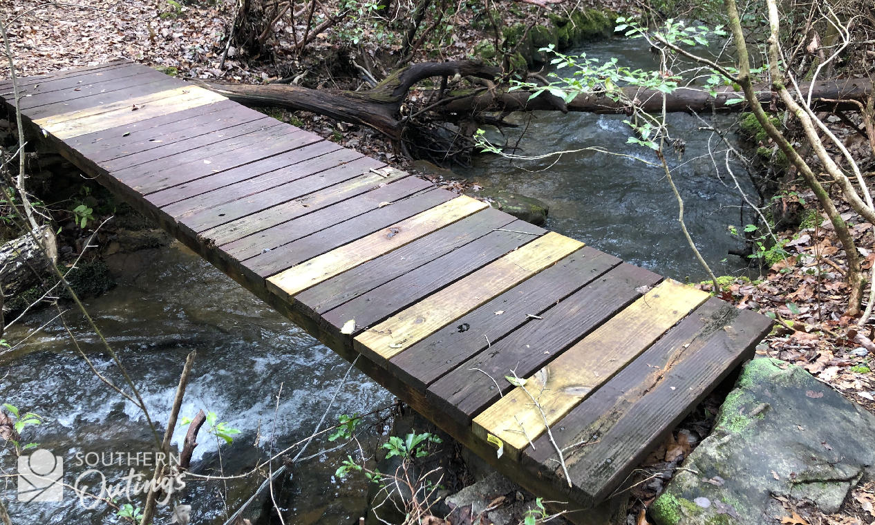
The Violet Trail leads down to the DST from the lodge parking lot. On the north side, you can get to the DST from either side of the pool via the Aqua Trail, which has one of the rhododendron “tunnels” I mentioned above. The trail crosses a mountain stream.
Elevation info: Altitude minimum for the DeSoto Scout Trail found within the state park is 1,353 feet above sea level; altitude maximum is 1,455 feet above sea level
Trailhead pinpointer: There are over half a dozen short paths that lead to the DST including ...
Explore the mountain’s rolling crest on the White Trail
An old path that follows the contour of Lookout Mountain on the northern side of the state park, the White Trail seems longer than two miles due to the rolling elevation changes and the variety of forest settings. Expect to see two ravines filled with tall hardwoods, plus large sandstone rock formations, and some wildlife.
The western end of the White Trail is near the park’s highest elevation, about 300 feet higher than at the eastern end.
Hikers and mountain bikers share this trail. There’s a rock quarry on the trial’s western half. The Civilian Conservation Corps used the rock from the site in the 1930s-40s to build the park’s cabins, picnic pavilions, culverts and other structures.
Listen for woodpeckers and watch for deer on this trail, especially as you pass across the top of the ravines.
On the trail’s east side, it passes near to an 8.5-foot tall fence at the park border with neighboring private property. I mention it because I’ve seen adult deer jump the fence. Not far from the fence, you'll see a giant boulder with a weird knob. It looks a little like a tail or small head on a dinosaur. See the photo in the gallery below.
I’ve also been awe-struck when hiking through this trail’s ravines. The canopies can be as soothing, stirring or inspiring as the sights and sounds of the river. Imagine walking under 100-foot treetops in a mountainside ravine as the wind rises up from the valley.
Length: 2 miles one-way (return the same way or use the Knotty Pine Mountain Bike Trail to connect to other trails in the center of the park)
Elevation info: Altitude minimum is 1,475 feet above sea level; altitude maximum is 1,785 feet above sea level
Trailhead pinpointers: Access the east end of the trail across from the country store driveway (map).
You can also access the White Trail by walking north from the trailhead parking area that shown as the Lost Falls Trailhead on Google maps.
You can also get to it from a short connecting path across from the RV campground entrance (map).
Enjoy easy access to one of the park’s cascading streams on the Talmadge Butler Boardwalk Trail
Named for the superintendent who managed the park for almost three decades, the boardwalk will take you over 350 yards into a beautiful, relatively flat part of the state park. There are two large observation decks that overlook the picturesque mountain stream. The deck at the end of the boardwalk straddles the water at a feature known as Azalea Cascades (The boardwalk route was formerly called Azalea Cascades Trail, by the way).
Large signs found at the boardwalk entrance indicate that the state park is Site #47 of the North Alabama Birding Trail, and the path certainly is a fantastic place for spotting birds that are typically found in southern Appalachian forests.
It also provides an easy way to walk among hardwood trees during the fall color display. You can get to the Orange, Red and Blue Trail from the boardwalk, so it’s a good starting point for hikers wishing to go further upstream to visit the stream’s other small waterfalls: Laurel Falls and Lost Falls.
Get to Laurel Falls and Lost Falls on the Blue Trail or the Orange Trail
Laurel Creek produces Lost Falls, Laurel Falls, Azalea Cascade and Indian Falls all within a 3/4-mile stretch of tiny waterway.
The Blue and Orange trails both allow you to hike through the forest from east to west while remaining parallel to the lovely little creek with a trail on each side of the it and its waterfalls.
At its western terminus, the Blue Trail dead ends into the Orange Trail. That makes hiking out on one of them, and then returning on the other a great choice. That hike would be about 3.5 miles. From where the trails come together, the Orange Trail continues north to the multi-trail trailhead area at the road.
From DeSoto Parkway, it’s only about 350 feet between the trailheads of the two trails. In addition, the boardwalk entrance is only a few yards from the start of the Blue Trail. Since the three trails converge near Azalea Cascade, you could start and end your Blue/Orange loop at the viewing deck found there, and enjoy all three trails on one hike.
Other than the waterfalls, highlights on the Blue Trail include an enormous tulip poplar tree right on the path, sandstone formations and a flat area at the western end that can be swampy during wet weather.
Highlights of the Orange Trail include walking among the giant boulders near the country store that are now home to some of the zip-line course, and some interesting mountain hollow terrain.
NOTE: The short Red Trail runs parallel to the Orange Trail from the country store to the Azalea Cascade. It also passes the giant boulders and zip-line course just a few yards from the country store.
You’ll enjoy the near-constant sound of the water from both trails. That big poplar tree is near the eastern end of the Blue Trail only a few hundred feet from Azalea Cascade.
Dissect the upper park terrain on the Silver Trail
The Silver Trail runs east to west much like the Blue and Orange trails, but this trail takes you to higher grown by paralleling the road rather than the stream. It will take you on a loop next to the road along the north side of the RV campground, and through the dense headwater forest on the gentle slopes on its west side.
It’s eastern portion is a popular path for campers who want to get to the country store, the zip-lines or maybe even all the way to the river or swimming pool. Mountain bikers use it to complete a White Trail/Silver Trail loop.
The Silver Trail is a good route for watching for birds like woodpeckers, grosbeaks, tanagers and even buntings. It’s good for seeing how the terrain and vegetation changes as the elevation rises. It has a couple of wet-weather streams of its own, but it has to be really wet. And, of course, it’s another good area for enjoying the color change in the fall.
The official state park trail map shows the Silver Trail crossing the road at the Lost Falls multi-trail trailhead. Signs for that section now show it as part of the Family Loop. Whatever you call that section, you can get to the White Trail that way.
Length: 1.35 miles one-way from the country store to the Lost Falls multi-trail trailhead
Elevation info: Minimum of 1,476 feet, maximum of 1,712
Trailhead pinpointers: At country store driveway (map)
Get a close look at the Sharp Branch on the Aqua Trail
With a short route behind the swimming pool that will take you on a loop around the Sharp Branch, the Aqua Trail provides an easy way to enjoy that mountain stream, as well as, an area of dense rhododendron and mountain laurel growth. It’s also an easy way to access the DeSoto Scout Trail. There’s a rock shelter right on the trail.
You’ll find all that only a few yards behind the swimming pool.
At north end of a connecting path at power-line clearing (map)
The short but steep hike to Lodge Falls
Those who want to visit each of DeSoto State Park’s small waterfalls can get a closeup look at Lodge Falls by venturing down a short, steep spur found along the Green Trail. The waterfall is only a few yards from the lodge’s backyard. Get to the Green Trail from the Violet Trail’s entrance in the front of the lodge (map).
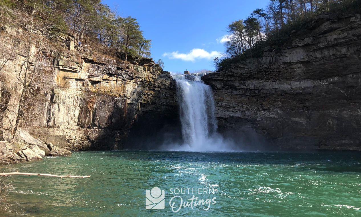
Hike to the bottom of DeSoto Falls
Outside of the DeSoto State Park primary property, the epic 107-foot DeSoto Falls is 5.9 miles north of the Talmadge Butler Boardwalk Trail parking lot. The state park oversees the falls property, and there’s a fun hiking trail to the pool at the bottom of the falls.
Highlights — other than the sights and sounds of the 100-foot high waterfall where the water flow can range from a trickle to a near-overwhelming torrent — include some nice bluff rocks that you can walk right up to, and some nice woods.
DeSoto Falls, Little River Falls at the canyon and Noccalula Falls in Gadsden are the three most-visited and most-photographed waterfalls in the state, and they are all on Lookout Mountain in northeast Alabama.
Length: About 0.6 miles one-way
Elevation info: 1,523 feet above sea level at the edge of the pool, and 1,618 at the top
Only 7.5 miles from historic downtown Fort Payne and 7.5 miles from the heart of Mentone, DeSoto State Park provides some of the easiest access to nature you will find in the region. Some of the most beautiful forests found anywhere on Lookout Mountain are inside the park’s borders.
There’s no better place in Alabama to listen to the sound of a river crashing and splashing its way through rugged mountain terrain, or to see wildflowers. Where else can you see four small waterfalls within a 4,000-foot radius, and then drive only six miles to see one of the most spectacular big waterfalls in Alabama?
With an official trail distance totaling about 20 miles, there are several other trails at the state park other than the ones featured in this article. Many are good for connecting to the best trails, and others are newer trails developed for the mountain-biking community with lots of extra curves and switchbacks to make them more enjoyable for those on two wheels. They are generally not as scenic and have less features such as streams, waterfalls and rock formations.
But, you cannot go wrong on any of the trails especially if you want to use a series of paths to circumnavigate the western park of the park, or customize a hike to your preferred distance.
View this page in digital magazine format
If you have come across this article while using a tablet, laptop or desktop computer, check out the digital magazine version of my hiker’s guide to DeSoto State Park's best trails.