Where to access the Silver Comet Trail in Georgia and the connected Chief Ladiga Trail in Alabama, with a helpful trailhead map and over 30 photos
Alabama’s 32-mile Chief Ladiga Trail and Georgia’s 62-mile Silver Comet Trail meet at the state line. The result is one of the best paved rail-to-trail paths in the South for bicycling, and a great Southern outing.
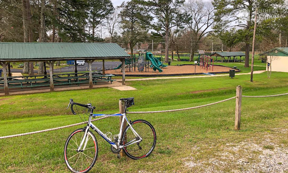
There are several easy-to-find trailheads along the 94-mile path where cyclists, inline skaters, skateboarders, joggers and walkers can access the trails, or where they can find a good place to take break.
Let’s take a look at where you can go to access the Chief Ladiga Trail or Silver Comet Trail.
The map shows each of the trailheads starting in Alabama moving from west to east. I also include the city parks that are on — or connected to — the path, as well asmost of the trail spurs that have been built to connect neighborhoods to the main path.
The 11 Alabama trailheads and the 22 Georgia trailheads, including the connecting paths, are numbered from 1 to 33 on the map.
Trailhead Quick Guide
This FREE 8-page quick guide includes the map, all the contents of this article and more.
The trailheads: From one end of the path to the other
Below is a brief description for each of those trailheads. I have also included some observations that may be helpful for cyclists who are planning to visit the Chief Ladiga and/or the Silver Comet.
In addition, parking in a shade can be a very big factor in deciding where to start an epic bike ride in the summertime. With that in mind, I have labeled the trailheads where you will most likely have the opportunity to park in a shade with “SHADED PARKING” in all caps.
Found at the western/southern terminus of the Chief Ladiga Trail, for those traveling to the east, this is where the Chief Ladiga begins. The park is operated by the city of Anniston. Highlights include newer restrooms and SHADED PARKING in the summer. Advance reservations and payment is required for the 16 campsites found there.
Michael Tucker Park: The end of the trail in Alabama
GOOD NEWS: In 2017-18, the city of Anniston approved plans to extend the Chief Ladiga Trail as far as the Amtrac station, 7 miles to the south of the present terminus. Land acquisition began after a state grant was awarded.
Just less than one mile north of Michael Tucker Park, the trail passes right through the heart of the quiet, small city of Weaver. The Weaver park has parking, picnic tables, restrooms and more.
In the area behind the Jacksonville Walmart, it would be a good optional place to start a Chief Ladiga Trail ride. You could park at one of the schools or the football stadium found there. For a supply stop, Walmart, Taco Bell and a convenience store are 0.08 mile to the east of the trail.
Shown as #4 on my map, this new trailhead was added in 2017 by the city of Jacksonville. They built a paved lot with about 20 parking spaces and a sidewalk. The big oak trees are great for taking a break. A couple of concrete pads make it appears that they will add restrooms and/or a shelter.
Here, Jacksonville provides another spur that connects to the big trail. As a ride starting point, there’s ample parking encircling the center complex. There’s restrooms in the pavilion adjacent to the soccer fields near where the spur connects to the parking lot. A concession stand is open during soccer games.
The spur that leads to the Jacksonville Community Center
6. Jacksonville Train Depot 650 Mountain Street NW; Jacksonville, AL The parking lot entrance is on Woodward Avenue Owned and operated by the city of Jacksonville Parks & Recreation Dept.: 256-435-8115
The city restored this c. 1860 depot to serve as a trailhead, rest stop and event venue. It has about 20 parking spaces and restrooms.
7. Jacksonville State University on campus trailhead Click the link above or the photo below and the linked map will guide you to this spot at the corner of Miller Street just north of the red brick fraternity houses. There’s a paved parking lot with about 16 spaces and a shelter.
Next,The Nisbett Street (Alabama Hwy. 204) trailhead is not currently open. The small shelter was destroyed by the March 19, 2018 tornado, and the tiny parking lot is blocked off by a small fence.
8. Germania Springs Park 540 Roy Webb Road; Jacksonville, AL Owned and operated by the city of Jacksonville Parks & Recreation Dept.: 256-435-8115
More often than not, we start our bicycle rides here at Germania Springs Park which is on the northern edge of Jacksonville. It’s a nice, well-kept park with a SHADED PARKING lot, bathrooms and a spring-fed stream.
9. Piedmont Sports Complex Sports Complex Drive; Piedmont, AL City of Piedmont: 256-447-3367
This is a youth sports facility with a large parking lot. The restrooms are inside the fenced area, so they are only accessible when ball games or practices are taking place. A trail spur connects the complex to the main trail.
10. Eubanks Welcome Center (click for Google map) 202 Dailey Street; Piedmont, AL 256-447-3363 Owned by the City of Piedmont and staffed by friendly volunteers Hours: 8 a.m.-4 p.m.
The welcome center is located at a nice old house. They have a bathroom in the house, and also mens and ladies bathrooms in a separate building. The two porches and a gazebo are each a nice place for a break.
The water fountain in the house has cold water. There is also a water fountain at the separate restroom building. They have a big parking lot which can usually end up about 80-85% full on Saturdays when the weather is nice.
Above: A path intersection at Piedmont and some scenes from the Eubanks Welcome Center
The Chief passes through the heart of Piedmont, so there are many other options for parking nearby including churches and the downtown commercial area.
This is a nice, paved, remote parking area with room for about a dozen cars. Maintained by Cleburne County, AL. There are no restrooms or shelter. Nine miles east of Piedmont, it’s an excellent place to start a short ride on the part of the trail that’s in, or near, the Talladega National Forest, or if if you want to avoid going into the city to park.
I believe the gravel parking lot is maintained by Polk County, GA. Only 0.44 miles from the Alabama/Georgia line, it features SHADED PARKING.
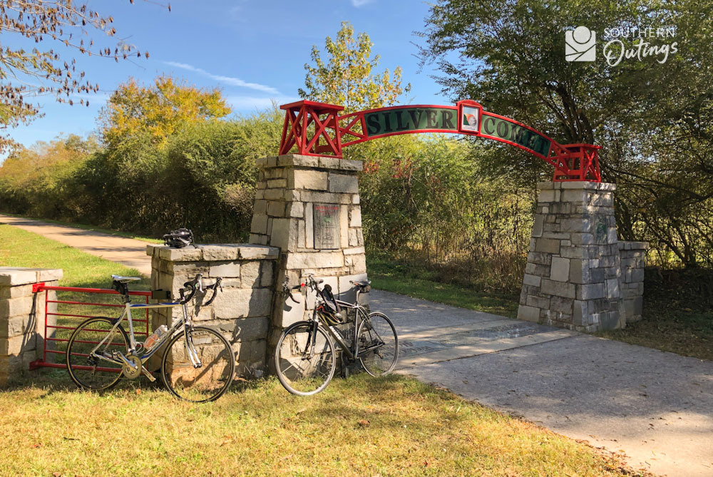
NOTE: Most cyclists stop for a break at the state line. For those traveling west on the trail, this is where the Silver Comet Trail ends and the Chief Ladiga Trail begins. The Gateway Park found there is maintained by Cleburne County, AL. There is shade, a shelter and a tall stand of pine trees. It’s often a turnaround point for riders who started in Cedartown, Piedmont, Rockmart, Jacksonville, Dallas, or even places further out.
At the state line where the Chief Ladiga and Silver Comet converge
You can only get to it via the Chief Ladiga Trail or the Silver Comet, and there are no restrooms or parking lot.
Canal Street is also U.S. Hwy. 278 and 100, as well as, GA Hwy. 6. There’s a gravel parking lot and usually a portable toilet at this site.
It’s at the western end of a section of the trail that leaves the old railroad bed before converging with it again 16 miles later just south of downtown Rockmart. The trail does run parallel to the currently-used train track for a good portion of that 16 miles. It also crosses the track five times in that stretch.
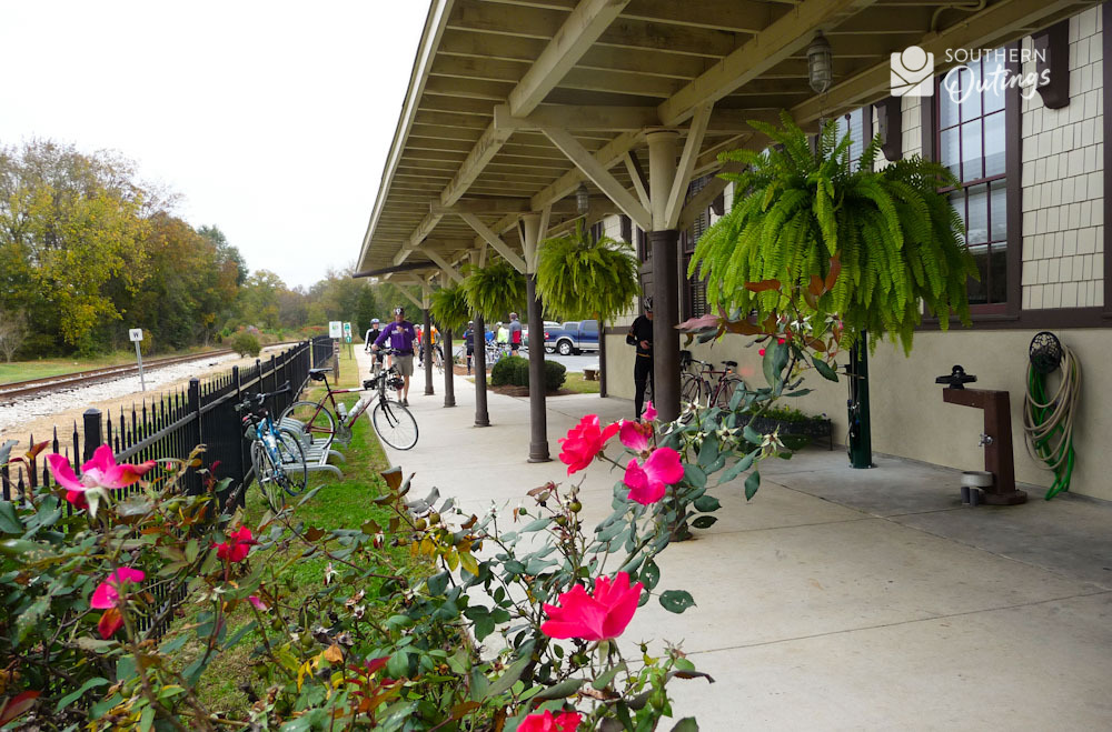
14. Cedartown Welcome Center (Depot) 609 South Main Street; Cedartown, GA Operated by the city of Cedartown 770-748-2090 Hours: 9 a.m.-5 p.m.
Located at a replica of the depot that was torn down in the 1970s (passenger train service was discontinued in 1969), they have water fountains with cold H2O and extremely clean bathrooms. They sell snacks and sports drinks. The paved parking lot has about 20 spaces. You could get a shady spot, but there’s only a couple.
The depot also serves as a little museum about the city’s history. It’s a good place to learn about one of Cedartown’s most famous natives: mid 20th-century Hollywood actor Sterling Holloway.
Cedartown Welcome Center (Depot) on the Silver Comet Trail
FUN FACT: Cedartown is also the hometown of Cleveland Browns running back Nick Chubb and country music star Sam Hunt.
15. Grady Road Trailhead Grady Road, 5.9 miles east of Cedartown Welcome Center (by car)
This Silver Comet trailhead’s lot has space for about 12-14 cars, and it’s maintained by Polk County. Just off U.S. Hwy. 278 between Cedartown and Rockmart, it sits across from the Grady Road landfill entrance.
You probably won’t mind the landfill visually. It’s mostly hidden by trees. It’s actually a very beautiful, hilly area in spite of the landfill. But you may not enjoy the smell in this section if the wind is out of the south.
Also maintained by Polk County and easy to get to from U.S. Hwy 278, it features a paved lot with 15-16 marked spaces and a portable toilet. There are a couple of SHADED PARKING spaces in the afternoon.
A scene about 0.60 mile east of the Don Williams Trailhead
17. Nathan Dean Park 100 Industrial Drive; Rockmart, GA Rockmart Recreation Dept. 770-684-5454 | Webpage
This is primarily a youth sports complex with 5 or 6 acres of parking area (there are some SHADED PARKING spaces in the afternoon), picnic pavilions, a few trees, and restrooms next to each cluster of ballfields.
Euharlee Creek flows through the park. A small footbridge, the Silver Comet bridge and the Elm Street bridge cross the creek to connect the north side of the park to historic downtown Rockmart.
The park also features big oak trees, pavilions, walking paths and a depot-style building. All that along with a veterans memorial make for a picturesque greenspace and an excellent place to access the trail.
The best parking is around the red brick building that has the veterans memorial in the yard. The building is considered to be the Rockmart Silver Comet Trailhead. Look for the eight flags. Free parking, including some SHADED PARKING, is on all four sides of the block. Restrooms are inside that building as well as the nearby depot.
A gravel lot in a lovely wooded area with SHADED PARKING, this trailhead has a path of about 200 feet in length connecting the parking area to the Silver Comet. It’s just outside the Rockmart city limits, and it’s maintained by Polk County.
It may be one of the best places along the trail for horse trailers, and there is a convenience store nearby.
This site is probably Polk County’s most popular Silver Comet trailhead. The paved parking lot has about 22-24 spaces and it’s always pretty full when the weather is good. SHADED PARKING under the pines is possible.
It’s popularity is due to it being the best place to bike, walk or jog into the Paulding Forest Wildlife Management Area and to see the Brushy Mountain Tunnel, which is only 2.5 miles away.
Above: A Coot’s Lake Beach Trailhead scene and Brushy Mountain Tunnel on the western edge of the Paulding Forest WMA
There are two portable toilets at the trailhead. A convenience store is only a few yards away.
NOTE: There are some incredible forest vistas as the trail passes through the Paulding Forest WMA. Although you are constantly passing through steeply-sloped ridges and ravines, the old, raised railroad bed provides an amazingly flat route over the 8-mile span.
There are about 36-38 parking spaces in the paved lot, picnic tables and a portable toilet. The SHADED PARKING lot was completely full the last time we passed. The site gets its name from the business that’s found next door: Rambo Nursery.
The large nursery grows annuals, perennials, roses and other plants exclusively for The Home Depot. It’s not open to the public.
The Rambo Trailhead is only 0.60 mile from the Pumpkinvine Trestle, the former train bridge that is over 700 feet long and about 150 feet high.
A couple of cyclists head into the treetops on the Pumpkinvine Trestle
Check out this video provided by Paulding County. It has some good footage of the sights you’ll see on this section of the trail.
Paulding County has some other Silver Comet Trail videos on their website VIDEO PAGE.
You may see it listed as the Tara Drummond Memorial Park, and it does have a park-like setting with some good shade and pretty landscaping. There is a restroom building, water fountain, and a paved lot with 36-40 parking spaces. A few of the spaces provide SHADED PARKING.
Tara Drummond Trailhead
23. Paulding Chamber Trailhead Park behind the Chamber of Commerce 455 Jimmy Campbell Pkwy.; Dallas, GA 770-445-6016
With over 60 parking spaces with some morning shade and a steep, winding path of about 500 feet in length leading to the Silver Comet, this trailhead is an excellent place to start a bike ride. They have a nice shelter next to the Chamber office building.
Paulding Chamber Trailhead
They have restrooms inside the building’s lower floor, but it’s locked up on weekends.
Luckily, there’s a concrete path (shown as the Dallas Trail Connect on Google maps) that leads to a business area about 0.36 mile to the east where you will find a Walgreens, a Chick-fil-A, a Waffle House and a Wendy’s.
There’s also four other restaurants and a Kroger across U.S. Hwy 278 at the same traffic light.
24. Hiram Trailhead Seaboard Avenue; Hiram, GA Paulding County: 770-445-8065
This trailhead features a red caboose plus parking on both sides of the trail with some SHADED PARKING. The Homer Leggett Memorial Park is next door. There are no restrooms or water fountains, but a major shopping area with a Home Depot, Walmart, Sam’s Club and over a dozen restaurants is only half a mile to the north.
Boneshaker Bicycles, a shop that rents bikes for use on the trail, is nearby. The trailhead has about 90 spaces, a large percentage with SHADED PARKING in the summer, along with a nice restroom/shelter building, water fountains and picnic tables.
A Silver Comet scene just east of the Florence Road Trailhead
An easy alternative to parking at an official Silver Comet trailhead, you can park at either end of this trail and make your way to the Silver Comet.
There is a small parking lot with SHADED PARKING at the northern end of the Lucille Creek Trail where you can travel through a wooded area along the creek for about 0.78 miles before connecting to the Silver Comet.
It continues to follow the creek in the woods another 0.40 mile south of the Silver Comet until it meets the Powder Springs Dallas Road/Marietta Street. At that road, the Lucille Trail continues another 0.63 mile as a sidewalk into the historic downtown Powder Springs area where there is plenty of parking including those at the new-for-2020 Town Green amphitheater park.
27. Powder Springs Silver Comet Linear Park (Some maps show Kids Park; some sites list it as Richard D. Sailors Trailhead) 1301 Richard D. Sailors Pkwy; Powder Springs, GA City of Powder Springs 770-943-1666 | Webpage
There are 90-plus parking spaces at this nicely-landscaped green space wedged between the Silver Comet and the Sailors Parkway. In the summer, you can enjoy afternoon SHADED PARKING when you return from an epic ride.
A building with a concession stand and restrooms is only a few yards from the trail. It, along with a pavilion filled with fitness stations, provide good shade for passing cyclists in need of a break.
Here, you’ll find about 25 parking spaces only about 10 feet from the trail. A few cars can enjoy SHADED PARKING. There are no restrooms or water fountains.
The southern terminus of Powder Springs’ 1.5 mile Wildhorse Trail is at the site. That trail follows a creek through a densely wooded area. See the next listing for more about that connecting trail.
There is a large lot with afternoon SHADED PARKING at the park on Macedonia Road at the north end of the Wildhorse Trail as well as at the county park/recreation center complex next door. Restrooms and water are available, but sometimes only when youth sports are taking place. It’s certainly an excellent option for connecting to the Silver Comet.
This one offers many amenities. Only a little over 4 miles from the trail’s original starting point, there’s a bike shop, restrooms, water access, a convenience store, a bus stop and over 100 parking spaces that are shared with the county park-and-ride service. The spaces on the wooded side provide SHADED PARKING for much of the day.
Abundant shopping and dining opportunities are 1 mile to the south and 0.06 mile to the north. If you choose to go south, the still-new 2-plus mile Floyd Road Trail is a concrete path that was made for that. It should also be considered another way to connect to the Silver Comet since you could park at one of the big shopping plazas, a park-and-ride lot, the amphitheater or school.
Here, you would find about 35 parking spaces, many of which offer afternoon SHADED PARKING, and a block building with a water fountain, restrooms, picnic tables and shelter. It’s a beautiful residential area with a covered bridge nearby.
What was a gravel parking lot not too long ago is now paved and has 22 marked spaces. That’s all. No other features are found here. To get to the Silver Comet, you must cross the busy East-West Connector at the light about 200-250 feet to the north.
33. Mavell Road Trailhead 4573 Mavell Road; Smyrna, GA Originally the eastern end as far as a concrete bike path is concerned, this is where the Silver Comet Trail officially begins. Mile marker zero is at this site. Now the Silver Comet Cumberland Connector extends the path into the busy commercial area to the east and beyond.
There are 75-80 parking spaces, restrooms, picnic tables and shelter. Most of the lot provides SHADED PARKING.
As with the Floyd Road Trail above, the connector makes it easy enough to start a Silver Comet ride from one of the shopping centers, a school or park. Hopes are to extend it further. It could be possible in the future to ride from the Silver Comet to the Atlanta Beltline. In addition, Cobb County has a master plan that would connect all the cities within the county.


 A Silver Comet scene just east of the Florence Road Trailhead


