
Exploring the TVA Cave Mountain Trail at the Guntersville Dam

There's more to discover on this short trail than the name implies. When folks walk right up to the cave entrance that appears to be chiseled into the limestone bluff on the north side of the small, oval-shaped mountain, they are not surprised. But, few people will expect to see a swamp at the base of the mountain within a few yards of the cave.
The shortest of three trails located near the TVA Guntersville Dam, the Cave Mountain Trail provides explorers an opportunity to enjoy wildflowers, giant hardwood trees, rock formations and — thanks to the swamp — a great place for birdwatching. Read on for more details about visiting the trail which is about 10 miles from Arab and 12 miles from downtown Guntersville.
Enjoy an easy hike to the cave
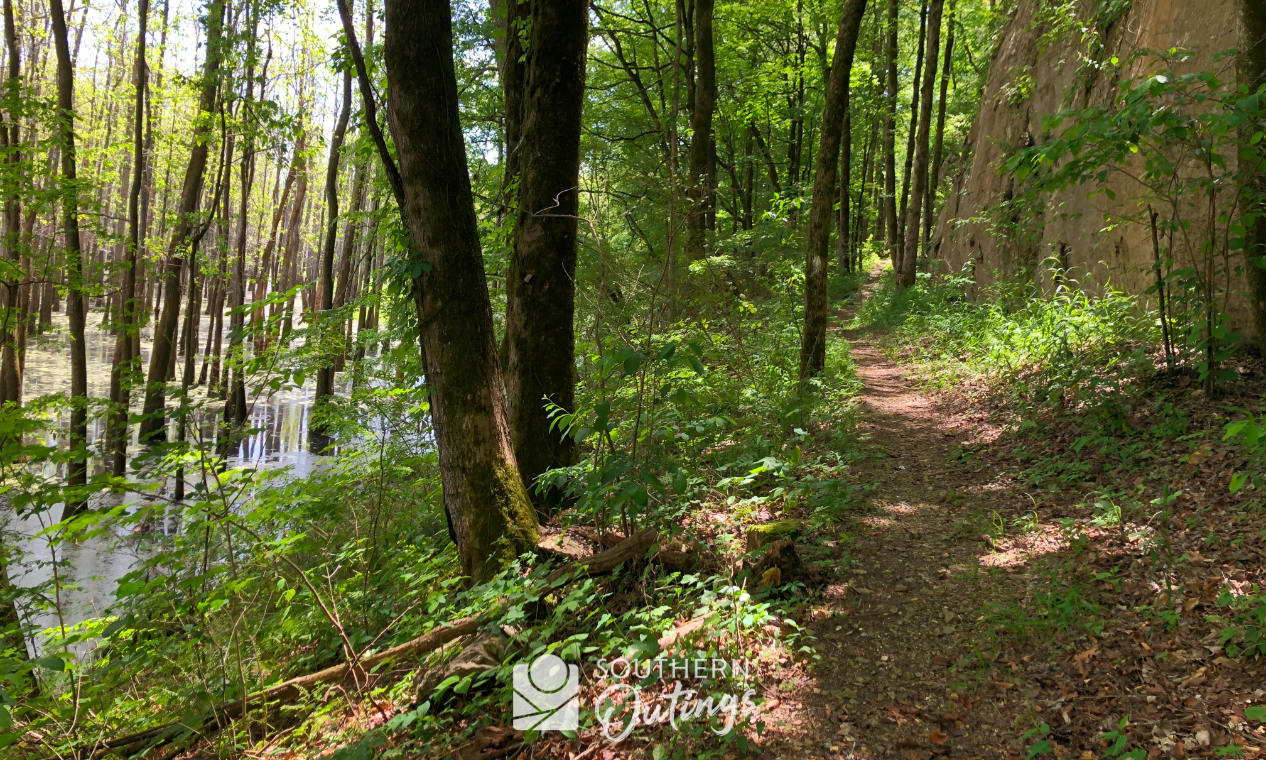
If you're coming from Huntsville, the Cave Mountain Trail is only 22.7 miles from Hobbs Island Road. Be sure to cross the river on Hwy. 231 towards Arab. If you travel on the other side of the river, the trip is much further since you can't get to the south side of the dam from the north side of the dam. After driving down the steep Snow Point Road, you will see the parking lot on the left. Head to the trail, and whether you go clockwise or counterclockwise on the loop, you will encounter large boulders and a densely wooded ravine setting. Seasoned hikers will find the hike to be easy. Others would describe it as moderate, especially during hot weather. Most of the trail is rather smooth and surprising flat although there are some rocky places. Over three-tenths of a mile of trail is located right up against a wall of limestone.


The steepest spot you will encounter is found at the northern tip of the mountain where you will make your way up or down some steel stairs.

The stairs are only about 100-150 yards from the cave.
The elevation changes of this short hike are not significant. The parking lot is about 575 feet above sea level. The cave is about 600 feet above sea level. The primary trail peaks at about 675 feet above sea level. The TVA's map of the trail shows an alternate path that crosses near the rocky peak of Cave Mountain which is about 805 feet above sea level. That map also shows 1.4 miles. I believe that is the total of both paths, so the primary trail is about a mile. The secondary path that goes to the top of the mountain is hard to locate due to lack of use. But since the TVA allows hikers to venture off the trails on most of the undeveloped lands it manages, it's OK to make your way to the mountaintop whether you find that alternate path or not. There is a bluff view of the river, dam and surrounding mountains to enjoy up there when the trees are bare during the winter.
NOTE: To protect the bats and the historical significance of the cave, a steel barricade was installed at the entrance in 2024.


Small Wild Area
The trail circumvents the small mountain while taking you through the 34-acre Cave Mountain Small Wild Area, one of TVA's 16 SWAs with trails found scattered around the Tennessee River Valley. SWAs are described by TVA as “sites with exceptional natural, scenic or aesthetic qualities that are suitable for low-impact public use ...”
See these TVA webpages for more about the Small Wild Areas:
Hiking in the Wild, Trails through Small Wild Areas
Some Civil War history
The cave has some Civil War significance. It was mined for saltpeter, a base ingredient in gunpowder, during the war.
Birdwatching, wildlife, flora and fauna

The swamp next to the cave can be great for birdwatching any time of year. Large waterfowl and birds of prey are easy to spot at times. Great Blue Heron are very common in north Alabama. At least one osprey nest can be seen on the power transmission towers.

December through early March, watch for migratory waterfowl such as teals, coots, widgeons and pelicans. Don't be surprised to also hear or see gulls, hawks, woodpeckers, grackles, kingfishers or many more of the 170-plus bird species that are known to be observed in the area any time of the year.
Other wildlife common to the area include chipmunks, armadillos, muskrats, beaver and whitetail deer. The rocky bluffs are good habitat for snakes such as copperheads. I'm sure their relatives, water moccasins, inhabit the swamp. During warm weather months, ticks will be waiting for you on the thick vegetation that lines the sides of the narrow paths. Oakleaf hydrangea grows wild in many places along the trail. A big variety of wildflowers can be seen from April to September. Types of hardwood trees found in these woods include white oak, sycamore, tulip poplar, Ohio Buckeye and beech. A fine stand of Tupelo gum trees is found in the swamp which is part of a good-sized wetlands area formed where the Long Hollow Branch flows from the mountains to flat lands near the edge of the river.
More photos


Itinerary ideas
The trail at the Cave Mountain Small Wild Area is open to hiking only. Certainly, that includes trail running. It may be too short to for many to consider visiting just for a hike. So, plan to spend a good deal of time birdwatching or enjoying other activities while at these TVA lands. Taking in the sights at Cave Mountain is an easy addition to a recreational or educational visit to the nearby public area at the dam which offers some good spots for fishing from the shore, picnics and more. There are also some information displays at the dam:

Since the Cave Mountain Trail shares a trailhead parking lot with the 6-mile long TVA Cooley Cemetery Trail, it's easy to go to the other side of the road to add some distance. Horseback riding and mountain biking are allowed on that longer trail.
See also my article about the 9.3-mile TVA Honeycomb Trail, a fantastic path found on the north side of the dam, and Seven TVA sites worth adding to your north Alabama outdoor travel plans.